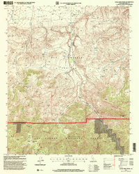
1995 Map of Eagle Rest Peak
USGS Topo · Published 2000About this map
The San Emigdio Grant bridges the transition from the flat agricultural expanse of the San Joaquin Valley into the steep northern slopes of the San Emigdio Mountains. At the valley floor, the San Emigdio Ranch sits near the mouth of several complex drainage systems, including Los Lobos Canyon and San Emigdio Canyon. The landscape is defined by its verticality, rising sharply toward the southern peaks of Brush Mountain and the high summit of Eagle Rest Peak. Evidence of early industrial activity is visible in the northeast corner of the map, where several Oil Wells and associated Oil Tanks are located. Much of the southern portion of the sheet is protected land within the Los Padres National Forest, where a network of springs and 4WD trails navigate the ridges and deep cuts like Devils Kitchen Canyon.
Find a feature on this map
29 named features on this map. Tap any name to fly to it.
Don’t see what you’re looking for? This feature index may not catch every label — zoom into the map to look around manually.
Map Details
Editions of this 1995 Eagle Rest Peak Map
This is the sole edition of this map. No revisions or reprints were ever made.
Other maps of this area

1903 · Mt. Pinos
USGS Topo · 1:125,000

1910 · Buena Vista Lake
USGS Topo · 1:125,000

1912 · Buena Vista Lake
USGS Topo · 1:125,000

1931 · Pentland Junction
USGS Topo · 1:31,680

1931 · Hayes Ranch
USGS Topo · 1:31,680

1933 · Hayes Ranch
USGS Topo · 1:31,680
1934 · Coal Oil Canyon
USGS Topo · 1:31,680

1934 · Pentland
USGS Topo · 1:31,680

1942 · Eagle Rest Peak
USGS Topo · 1:24,000

1943 · Apache Canyon
USGS Topo · 1:24,000