2023 Map of East Aurora
USGS Topo · Published 2023About this map
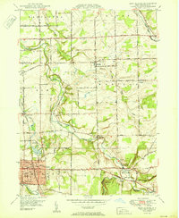
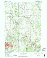
East Aurora serves as the primary hub of this Erie County landscape, where the East Branch Cazenovia Creek and Tannery Brook intersect the village grid. The area is defined by a series of small, established settlements like Marilla, Porterville, and Wales Center, each connected by a historically significant road network including Two Rod Rd and Four Rod Rd. These numeric road names reflect the early surveying and transit patterns of Western New York. The map reveals a high density of local history sites, particularly several burial grounds such as Maplewood Cem and Evergreen Cem. Natural drainages like Buffalo Creek and Cayuga Creek wind through the township boundaries, illustrating the hydrology that guided the placement of early centers like Elma Center and East Elma.
Find a feature on this map
114 named features on this map. Tap any name to fly to it.
Don’t see what you’re looking for? This feature index may not catch every label — zoom into the map to look around manually.
Map Details
Editions of this 2023 East Aurora Map
This is the sole edition of this map. No revisions or reprints were ever made.
Historical Maps of Aurora Through Time
3 maps found