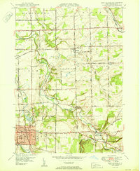
1950 Map of East Aurora
USGS Topo · Published 1950About this map
East Aurora anchors the southwestern corner of this survey, revealing the village's mid-century layout complete with its High Sch, the local Tannery, and Hamlin Park. The landscape is defined by the winding paths of Buffalo Creek and Little Buffalo Creek, which carve through a mosaic of agricultural plots and small hamlets like Wales Center, Marilla, and Porterville. This era shows a community still organized around rural education districts, as evidenced by several numbered schoolhouses including School No 1 and School No 7 scattered across the township lines of Aurora, Elma, and Wales.
Find a feature on this map
48 named features on this map. Tap any name to fly to it.
Don’t see what you’re looking for? This feature index may not catch every label — zoom into the map to look around manually.
Map Details
Editions of this 1950 East Aurora Map
This is the sole edition of this map. No revisions or reprints were ever made.
Other maps of this area

1905 · Attica
USGS Topo · 1:62,500

1905 · Depew
USGS Topo · 1:62,500

1923 · Arcade
USGS Topo · 1:62,500

1925 · Springville
USGS Topo · 1:62,500

1925 · Arcade
USGS Topo · 1:62,500

1948 · Depew
USGS Topo · 1:62,500

1949 · Attica
USGS Topo · 1:62,500

1949 · Cowlesville
USGS Topo · 1:24,000
1950 · Corfu
USGS Topo · 1:24,000
1950 · Lancaster
USGS Topo · 1:24,000