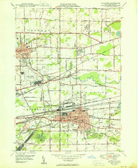
1950 Map of Lancaster
USGS Topo · Published 1950About this map
Ellicott Creek and Cayuga Creek wind through this mid-century landscape, framing the rapid post-war growth of eastern Erie County. The western edge is dominated by the Buffalo Municipal Airport, while the heart of the sheet reveals a dense corridor of transportation infrastructure, including the Lehigh Valley and New York Central railroads. These lines served the industrial and residential hubs of Depew and Lancaster, where urban street grids contrast sharply with the more open terrain of Harris Hill and Wilhelm to the north.
Find a feature on this map
51 named features on this map. Tap any name to fly to it.
Don’t see what you’re looking for? This feature index may not catch every label — zoom into the map to look around manually.
Map Details
Editions of this 1950 Lancaster Map
This is the sole edition of this map. No revisions or reprints were ever made.
Other maps of this area

1894 · Buffalo
USGS Topo · 1:62,500

1897 · Tonawanda
USGS Topo · 1:62,500

1897 · Lockport
USGS Topo · 1:62,500

1899 · Niagara
USGS Topo · 1:125,000

1900 · Tonawanda
USGS Topo · 1:62,500

1901 · Buffalo
USGS Topo · 1:62,500

1901 · Tonawanda
USGS Topo · 1:62,500

1902 · Lockport
USGS Topo · 1:62,500

1905 · Depew
USGS Topo · 1:62,500

1905 · Lockport
USGS Topo · 1:62,500