
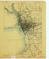
1894 Map of Buffalo
USGS Topo · Published 1894About this map
The industrial and maritime hub of Buffalo dominates this 1893 survey, showing a city defined by its position at the eastern terminus of Lake Erie. The riverfront is a dense network of piers and navigational aids, including the Buffalo Breakwater L. H. and Horse Shoe Reef L. H., marking the critical passage between the lake and the Niagara River. To the west, across the international boundary, the Fort Erie (Ruins) stand as a sentinel from an earlier era, while the International Bridge and the Erie Canal signify the commercial power of the late nineteenth century.
Find a feature on this map
76 named features on this map. Tap any name to fly to it.
Don’t see what you’re looking for? This feature index may not catch every label — zoom into the map to look around manually.
Map Details
Editions of this 1894 Buffalo Map
2 editions found
Other maps of this area

1894 · Niagara Falls
USGS Topo · 1:62,500

1896 · Niagara Falls
USGS Topo · 1:62,500

1897 · Tonawanda
USGS Topo · 1:62,500

1897 · Lockport
USGS Topo · 1:62,500

1899 · Silver Creek
USGS Topo · 1:62,500

1899 · Niagara
USGS Topo · 1:125,000

1900 · Tonawanda
USGS Topo · 1:62,500

1900 · Niagara Falls
USGS Topo · 1:62,500

1901 · Buffalo
USGS Topo · 1:62,500

1901 · Niagara Falls
USGS Topo · 1:62,500