
1897 Map of Lockport
USGS Topo · Published 1897About this map
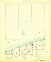
Erie Canal operations dominate the landscape of the late 19th-century Niagara Frontier, cutting a distinct path through Lockport and feeding into smaller transport hubs like Raynales Basin and Orangeport. The map illustrates a dense network of early industrial and agricultural infrastructure, where the New York Central and Hudson River RR and the Erie R. R. (Lockport Br.) compete with the established water routes. To the south, the meandering Tonawanda Creek defines the boundaries near Pendleton and Millersport, while the landscape is dotted with rural centers such as Swifts Mills and Wolcottsville. This 1896 survey by Frank Sutton and E.B. Clark captures the area before the modernization of the canal system, showing the original lock-dependent economy and the transition toward heavy rail transport across the Niagara and Erie county borderlands.
Find a feature on this map
47 named features on this map. Tap any name to fly to it.
Don’t see what you’re looking for? This feature index may not catch every label — zoom into the map to look around manually.
Map Details
Editions of this 1897 Lockport Map
This is the sole edition of this map. No revisions or reprints were ever made.
Other maps of this area

1894 · Buffalo
USGS Topo · 1:62,500
1894 · Wilson
USGS Topo · 1:62,500

1897 · Tonawanda
USGS Topo · 1:62,500
1897 · Olcott
USGS Topo · 1:62,500

1897 · Medina
USGS Topo · 1:62,500
1897 · Ridgeway
USGS Topo · 1:62,500

1899 · Niagara
USGS Topo · 1:125,000
1900 · Wilson
USGS Topo · 1:62,500

1900 · Tonawanda
USGS Topo · 1:62,500

1901 · Buffalo
USGS Topo · 1:62,500