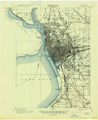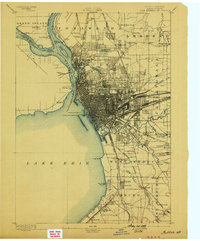
1894 Map of Buffalo
USGS Topo · Published 1899About this map
The Niagara River and Lake Erie waterfronts define this late-19th-century study of the Buffalo region, showcasing a massive industrial and transportation hub at its Victorian peak. The dense street grid of Buffalo radiates from the harbor, where the Erie Canal meets the lake behind a series of maritime structures like the Buffalo Breakwater L.H. and Buffalo L.H.. This era is marked by an extraordinary concentration of rail infrastructure, including the Belt Line and various routes of the Lehigh Valley R.R. and West Shore R.R. converging on the city center.
Find a feature on this map
75 named features on this map. Tap any name to fly to it.
Don’t see what you’re looking for? This feature index may not catch every label — zoom into the map to look around manually.
Map Details
Editions of this 1894 Buffalo Map
2 editions found

Historical Maps of Buffalo Through Time
8 maps found