
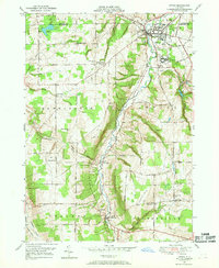
1949 Map of Cowlesville
USGS Topo · Published 1969About this map
Cayuga Creek winds through the heart of this western New York landscape, anchoring a network of small agricultural hamlets during the mid-century. The settlement of Cowlesville sits at a prominent bend in the creek, while other rural centers like Folsomdale and Bennington serve as focal points for the surrounding farmsteads. This 1949 topography, compiled in part from 1942 aerial photography, reveals a high density of rural schoolhouses, such as School No 20 and School No 14, indicating a localized social structure before widespread district consolidation.
Find a feature on this map
51 named features on this map. Tap any name to fly to it.
Don’t see what you’re looking for? This feature index may not catch every label — zoom into the map to look around manually.
Map Details
Editions of this 1949 Cowlesville Map
This is the sole edition of this map. No revisions or reprints were ever made.
Other maps of this area

1905 · Attica
USGS Topo · 1:62,500

1905 · Depew
USGS Topo · 1:62,500

1923 · Arcade
USGS Topo · 1:62,500

1925 · Springville
USGS Topo · 1:62,500

1925 · Arcade
USGS Topo · 1:62,500

1944 · Alexander
USGS Topo · 1:31,680

1948 · Depew
USGS Topo · 1:62,500

1949 · Attica
USGS Topo · 1:62,500

1949 · Alexander
USGS Topo · 1:24,000
1949 · Attica
USGS Topo · 1:24,000