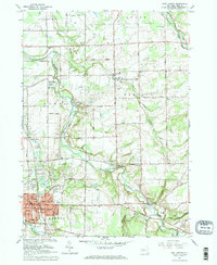
1965 Map of East Aurora
USGS Topo · Published 1967About this map
The village of East Aurora serves as a dense residential and civic hub in the mid-1960s, showing a concentrated grid of streets like Main Street and Oakwood Avenue alongside the local Library and Townhall. This era reflects a transition toward suburban development, with educational campuses such as Iroquois High Sch and Iroquois Jr High Sch established near the winding course of Buffalo Creek. Outside the village center, the landscape is defined by small crossroads settlements including Porterville and Wales Center, and a series of sequential roads known as Two Rod Road, Three Rod Road, and Four Rod Road. The map provides significant detail for genealogists, plotting numerous local landmarks including Maple Rest Cem, Evergreen Cem, and the Depew-Lancaster Camp near Cayuga Creek.
Find a feature on this map
90 named features on this map. Tap any name to fly to it.
Don’t see what you’re looking for? This feature index may not catch every label — zoom into the map to look around manually.
Map Details
Editions of this 1965 East Aurora Map
2 editions found
Other maps of this area

1905 · Attica
USGS Topo · 1:62,500

1905 · Depew
USGS Topo · 1:62,500

1923 · Arcade
USGS Topo · 1:62,500

1925 · Springville
USGS Topo · 1:62,500

1925 · Arcade
USGS Topo · 1:62,500

1948 · Depew
USGS Topo · 1:62,500

1949 · Attica
USGS Topo · 1:62,500

1949 · Cowlesville
USGS Topo · 1:24,000
1950 · Corfu
USGS Topo · 1:24,000
1950 · Lancaster
USGS Topo · 1:24,000