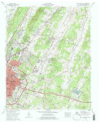
1976 Map of East Cleveland
USGS Topo · Published 1977About this map
Cleveland and its northeastern suburbs appear at a moment of significant growth in the mid-1970s, as urban expansion moves along the Southern Railway corridor and the newly established Interstate 75. The landscape is a series of distinct valleys, most notably Walker Valley and Chatata Valley, where agricultural patterns remain visible despite the encroachment of residential developments like Burlington Heights and Rolling Brook. Higher elevations such as Ridge and Dry Ridge create natural boundaries for these settlement pockets.
Find a feature on this map
105 named features on this map. Tap any name to fly to it.
Don’t see what you’re looking for? This feature index may not catch every label — zoom into the map to look around manually.
Map Details
Editions of this 1976 East Cleveland Map
This is the sole edition of this map. No revisions or reprints were ever made.
Other maps of this area

1886 · Cleveland
USGS Topo · 1:125,000

1892 · Cleveland
USGS Topo · 1:125,000

1895 · Cleveland
USGS Topo · 1:125,000

1901 · Cleveland
USGS Topo · 1:125,000

1935 · East Cleveland
USGS Topo · 1:24,000

1935 · Mc Donald
USGS Topo · 1:24,000

1935 · Calhoun
USGS Topo · 1:24,000

1935 · Benton
USGS Topo · 1:24,000

1935 · Felker
USGS Topo · 1:24,000

1935 · Charleston
USGS Topo · 1:24,000