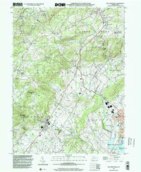
1999 Map of East Greenville
USGS Topo · Published 2002About this map
Perkiomen Creek winds through this Pennsylvania landscape where the borders of Lehigh, Berks, and Montgomery counties converge. The terrain is defined by the South Mountain range and the Furnace Hills, shielding a series of small, established villages including Old Zionsville, Seisholtzville, and Bally. This late-twentieth-century survey illustrates a region that maintained its traditional layout of scattered farmsteads and country crossroads even as modern infrastructure like a major pipeline and telephone line cut across the hills. The presence of numerous historic houses of worship, such as Huffs Church, St Peters Ch, and the New Goshenhoppen Ch, speaks to the deep-rooted community ties and German heritage prevalent in these townships. To the south, the expansion of Green Lane County Park around the Green Lane Reservoir indicates a shift toward conservation and public recreation alongside the local industry represented by the Sewage Treatment Plant and various utility corridors.
Find a feature on this map
62 named features on this map. Tap any name to fly to it.
Don’t see what you’re looking for? This feature index may not catch every label — zoom into the map to look around manually.
Map Details
Editions of this 1999 East Greenville Map
This is the sole edition of this map. No revisions or reprints were ever made.
Other maps of this area

1888 · Quakertown
USGS Topo · 1:62,500

1890 · Quakertown
USGS Topo · 1:62,500

1894 · Allentown
USGS Topo · 1:62,500

1894 · Quakertown
USGS Topo · 1:62,500

1902 · Boyertown
USGS Topo · 1:62,500

1902 · Slatington
USGS Topo · 1:62,500

1937 · Allentown West
USGS Topo · 1:48,000

1939 · Allentown
USGS Topo · 1:62,500

1942 · Norristown
USGS Topo · 1:125,000

1942 · Allentown West
USGS Topo · 1:62,500