
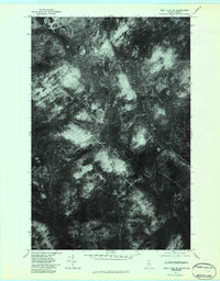
1976 Map of East Lake SE
USGS Topo · Published 1983About this map
Dense northern woodlands and logging tracks define this orthophotoquad of the Aroostook County wilderness. Produced by the U.S. Geological Survey from aerial photography taken in the autumn of 1976, the map reveals the intricate network of timber roads and drainage patterns typical of the Maine North Woods during the late twentieth century. While the landscape is largely devoid of formal settlements or major infrastructure, the winding course of the Branch provides a focal point for the natural drainage of the territory. The high-contrast imagery offers a clear view of forest composition and the geometric patterns of modern forestry management, preserving a visual record of this remote border region before later decades of regrowth and further logging changed the canopy profile.
Find a feature on this map
1 named feature on this map. Tap any name to fly to it.
Don’t see what you’re looking for? This feature index may not catch every label — zoom into the map to look around manually.
Map Details
Editions of this 1976 East Lake SE Map
2 editions found
Other maps of this area

1954 · Presque Isle
USGS Topo · 1:250,000

1955 · Rocky Mountain
USGS Topo · 1:62,500

1955 · Little East Lake
USGS Topo · 1:62,500

1955 · Round Pond
USGS Topo · 1:62,500

1955 · Seven Islands
USGS Topo · 1:62,500

1958 · Presque Isle
USGS Topo · 1:250,000

1960 · Presque Isle
USGS Topo · 1:250,000

1962 · Edmundston
USGS Topo · 1:250,000

1976 · East Lake
USGS Topo · 1:24,000
1976 · Ninemile Deadwater
USGS Topo · 1:24,000