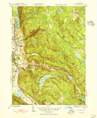
1945 Map of East Lee
USGS Topo · Published 1956About this map
The Housatonic River corridor serves as the industrial and transit heart of this Berkshire County landscape at the conclusion of the Second World War. The New York New Haven and Hartford railroad tracks parallel the river, connecting the manufacturing hubs of Lee, Lenoxdale, and Lenox. In contrast to the valley floor, the highlands to the east are dominated by the October Mountain State Forest and the winding path of the Appalachian Trail. This terrain is defined by a series of high-altitude water bodies, including Goose Pond, Finerty Pond, and Sandwash Reservoir. Historical local thoroughfares like Lenox Whitney Place Road and Schoolhouse Road provide access to the more isolated settlements of Washington and West Becket. The map captures the region's character as a mix of river-based industry and protected upland wilderness.
Find a feature on this map
56 named features on this map. Tap any name to fly to it.
Don’t see what you’re looking for? This feature index may not catch every label — zoom into the map to look around manually.
Map Details
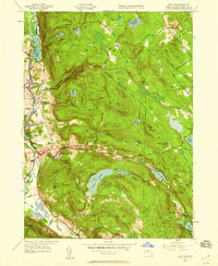
Editions of this 1945 East Lee Map
2 editions found
Other maps of this area

1885 · Sheffield
USGS Topo · 1:62,500

1886 · Becket
USGS Topo · 1:62,500

1888 · Sheffield
USGS Topo · 1:62,500

1888 · Becket
USGS Topo · 1:62,500

1888 · Sandisfield
USGS Topo · 1:62,500

1888 · Pittsfield
USGS Topo · 1:62,500

1890 · Pittsfield
USGS Topo · 1:62,500

1891 · Sheffield
USGS Topo · 1:62,500

1893 · Becket
USGS Topo · 1:62,500

1893 · Sheffield
USGS Topo · 1:62,500