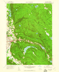
1958 Map of East Lee
USGS Topo · Published 1960About this map
October Mountain State Forest dominates the high ground of the Berkshires in this late 1950s survey, a landscape defined by its deep reservoirs and high peaks like Bald Top. The Housatonic River corridor serves as the industrial and residential heart of the region, where the New York New Haven & Hartford Railroad connects settlements like Lenox Dale and Lee. A significant moment in regional infrastructure is captured here with the presence of Interchange No 12 on the Massachusetts Toll Road Turnpike, illustrating the post-war shift toward high-speed highway travel that bypassed older mountain routes.
Find a feature on this map
59 named features on this map. Tap any name to fly to it.
Don’t see what you’re looking for? This feature index may not catch every label — zoom into the map to look around manually.
Map Details
Editions of this 1958 East Lee Map
This is the sole edition of this map. No revisions or reprints were ever made.
Other maps of this area

1885 · Sheffield
USGS Topo · 1:62,500

1886 · Becket
USGS Topo · 1:62,500

1888 · Sheffield
USGS Topo · 1:62,500

1888 · Becket
USGS Topo · 1:62,500

1888 · Sandisfield
USGS Topo · 1:62,500

1888 · Pittsfield
USGS Topo · 1:62,500

1890 · Pittsfield
USGS Topo · 1:62,500

1891 · Sheffield
USGS Topo · 1:62,500

1893 · Becket
USGS Topo · 1:62,500

1893 · Sheffield
USGS Topo · 1:62,500