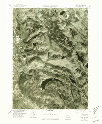
1975 Map of East Lee
USGS Topo · Published 1981About this map
Lee and East Lee serve as the primary population centers on this mid-1970s orthophotograph, situated where the valley floor meets the rising elevations of the Berkshires. The Housatonic River winds through the western portion of the map, supporting the industrial character of Lenox Dale while defining the low-lying drainage for the region. To the east, the landscape becomes increasingly dominated by substantial water bodies and forested terrain, including the large expanse of Goose Pond and the more remote Sandwash Reservoir to the north. This survey, based on aerial photography taken in late October, reveals the distinct interface between human settlement and the natural topography of the Berkshire highlands, providing an overhead perspective of the transportation corridors that link West Becket to the river valley commerce.
Find a feature on this map
8 named features on this map. Tap any name to fly to it.
Don’t see what you’re looking for? This feature index may not catch every label — zoom into the map to look around manually.
Map Details
Editions of this 1975 East Lee Map
This is the sole edition of this map. No revisions or reprints were ever made.
Other maps of this area

1885 · Sheffield
USGS Topo · 1:62,500

1886 · Becket
USGS Topo · 1:62,500

1888 · Sheffield
USGS Topo · 1:62,500

1888 · Becket
USGS Topo · 1:62,500

1888 · Sandisfield
USGS Topo · 1:62,500

1888 · Pittsfield
USGS Topo · 1:62,500

1890 · Pittsfield
USGS Topo · 1:62,500

1891 · Sheffield
USGS Topo · 1:62,500

1893 · Becket
USGS Topo · 1:62,500

1893 · Sheffield
USGS Topo · 1:62,500