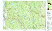
1987 Map of East Lee
USGS Topo · Published 1987About this map
October Mountain State Forest dominates the high ground of the Berkshires in this 1980s-era topographic study, providing a look at a landscape where conservation and heavy transit intersect. The Appalachian Trail winds through the interior hills, passing near Finerty Pond and Buckley Dunton Lake, while the Massachusetts Turnpike cuts a major east-west corridor through the valley below East Lee.
Find a feature on this map
80 named features on this map. Tap any name to fly to it.
Don’t see what you’re looking for? This feature index may not catch every label — zoom into the map to look around manually.
Map Details
Editions of this 1987 East Lee Map
This is the sole edition of this map. No revisions or reprints were ever made.
Other maps of this area

1885 · Sheffield
USGS Topo · 1:62,500

1886 · Chesterfield
USGS Topo · 1:62,500

1886 · Becket
USGS Topo · 1:62,500

1887 · Granville
USGS Topo · 1:62,500

1888 · Sheffield
USGS Topo · 1:62,500

1888 · Becket
USGS Topo · 1:62,500

1888 · Sandisfield
USGS Topo · 1:62,500

1888 · Chesterfield
USGS Topo · 1:62,500

1888 · Pittsfield
USGS Topo · 1:62,500

1889 · Granville
USGS Topo · 1:62,500