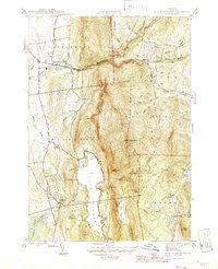
1946 Map of East Middlebury
USGS Topo · Published 1946About this map
Green Mountain National Forest dominates this mid-century landscape, where the steep ascent from the lowlands of Salisbury and East Middlebury gives way to high ridges and deep mountain brooks. The transition from the settled valley floor to the wilderness is marked by family-named landmarks like Bryant Mtn and Pine Hill. To the west, Lake Dunmore serves as a focal point, its eastern shore shadowed by the high cliffs of Mt Moosalamoo and the distinctive Rattlesnake Point.
Find a feature on this map
49 named features on this map. Tap any name to fly to it.
Don’t see what you’re looking for? This feature index may not catch every label — zoom into the map to look around manually.
Map Details
Editions of this 1946 East Middlebury Map
This is the sole edition of this map. No revisions or reprints were ever made.
Other maps of this area

1902 · Brandon
USGS Topo · 1:62,500

1903 · Middlebury
USGS Topo · 1:62,500

1904 · Brandon
USGS Topo · 1:62,500

1905 · Middlebury
USGS Topo · 1:62,500

1915 · Rochester
USGS Topo · 1:62,500

1917 · Rochester
USGS Topo · 1:62,500

1919 · Lincoln Mountain
USGS Topo · 1:62,500

1920 · Lincoln Mountain
USGS Topo · 1:48,000

1920 · Brandon
USGS Topo · 1:62,500

1920 · Middlebury
USGS Topo · 1:62,500