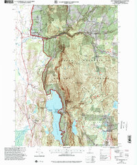
1997 Map of East Middlebury
USGS Topo · Published 2000About this map
Green Mountain National Forest dominates this landscape, where the high ridges of Mt Moosalamoo and Hogback Mountain overlook the recreational waters of Lake Dunmore and Silver Lake. The map reveals a transition from the agricultural lowlands near Salisbury and East Middlebury to the dense, wooded elevations of the interior. A notable concentration of literary and historical landmarks is found near Ripton, including the Robert Frost Interpretive Trail and the Robert Frost Wayside. Local genealogy and settlement history are anchored by several burial grounds like Prospect Cem, Cooks Cem, and Salisbury Cem, alongside the Plain Sch site. The topography reflects a well-established forest infrastructure, with numerous 4WD roads and trails like the Moosalamoo Trail and Leicester Hollow Trail connecting the ridges to the Branbury State Park Campground.
Find a feature on this map
49 named features on this map. Tap any name to fly to it.
Don’t see what you’re looking for? This feature index may not catch every label — zoom into the map to look around manually.
Map Details
Editions of this 1997 East Middlebury Map
This is the sole edition of this map. No revisions or reprints were ever made.
Other maps of this area

1902 · Brandon
USGS Topo · 1:62,500

1903 · Middlebury
USGS Topo · 1:62,500

1904 · Brandon
USGS Topo · 1:62,500

1905 · Middlebury
USGS Topo · 1:62,500

1915 · Rochester
USGS Topo · 1:62,500

1917 · Rochester
USGS Topo · 1:62,500

1919 · Lincoln Mountain
USGS Topo · 1:62,500

1920 · Lincoln Mountain
USGS Topo · 1:48,000

1920 · Brandon
USGS Topo · 1:62,500

1920 · Middlebury
USGS Topo · 1:62,500