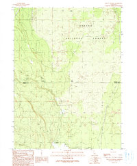
1990 Map of East of Pondosa
USGS Topo · Published 1990About this map
Shasta National Forest dominates this volcanic landscape along the border of Siskiyou and Shasta Counties. The terrain is defined by its geological history, with prominent lava flows marked in the eastern portion of the survey. Human activity is sparse, concentrated primarily around two specific junctions: Hammond Crossing, located where a logging road or trail meets Bear Creek, and Spalding Corner to the south. This 1990 provisional map records the infrastructure of the late 20th century, including industrial transmission lines and a pipeline cutting across the timbered landscape. The map captures a moment when the region's economy relied on the intersection of forest management and utilities, providing a specific record of rural Northern California crossroads before further modernization.
Find a feature on this map
11 named features on this map. Tap any name to fly to it.
Don’t see what you’re looking for? This feature index may not catch every label — zoom into the map to look around manually.
Map Details
Editions of this 1990 East of Pondosa Map
This is the sole edition of this map. No revisions or reprints were ever made.
Other maps of this area

1886 · Modoc Lava Bed
USGS Topo · 1:250,000

1892 · Modoc Lava-Bed
USGS Topo · 1:250,000

1932 · Bartle
USGS Topo · 1:96,000

1939 · Bartle
USGS Topo · 1:125,000

1954 · Alturas
USGS Topo · 1:250,000

1958 · Alturas
USGS Topo · 1:250,000

1961 · Hambone
USGS Topo · 1:62,500

1961 · Pondosa
USGS Topo · 1:62,500

1961 · Fall River Mills
USGS Topo · 1:62,500

1962 · Alturas
USGS Topo · 1:250,000