1995 Map of East of Pondosa
USGS Topo · Published 1997About this map
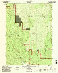
Shasta National Forest lands dominate this northern California landscape, showing the transition from the forested hillsides down into the volcanic flats marked by extensive lava beds. The 1995 revision reveals a network of timber and access roads, including many designated 4wd routes, illustrating the region's managed wilderness character. The border between Siskiyou and Shasta counties bisects the terrain, which is defined by the winding course of Bear Creek. Sparse human habitation is concentrated at small interior junctions such as Hammond Crossing and Spalding Corner, while the settlement of Dana sits along the eastern edge. A significant pipeline corridor cuts through the southeastern portion, marking a modern utility footprint across the volcanic geology.
Find a feature on this map
12 named features on this map. Tap any name to fly to it.
Don’t see what you’re looking for? This feature index may not catch every label — zoom into the map to look around manually.
Map Details
Editions of this 1995 East of Pondosa Map
This is the sole edition of this map. No revisions or reprints were ever made.
Other maps of this area

1886 · Modoc Lava Bed
USGS Topo · 1:250,000

1892 · Modoc Lava-Bed
USGS Topo · 1:250,000

1932 · Bartle
USGS Topo · 1:96,000

1939 · Bartle
USGS Topo · 1:125,000

1954 · Alturas
USGS Topo · 1:250,000

1958 · Alturas
USGS Topo · 1:250,000
1961 · Hambone
USGS Topo · 1:62,500
1961 · Pondosa
USGS Topo · 1:62,500
1961 · Fall River Mills
USGS Topo · 1:62,500

1962 · Alturas
USGS Topo · 1:250,000