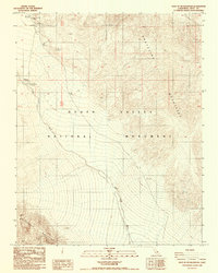
1988 Map of East of Tin Mountain
USGS Topo · Published 1988About this map
Death Valley National Monument serves as the focal point for this late-1980s landscape, illustrating the stark transition between the high desert peaks and the low alluvial washes. The Grapevine Mountains dominate the northeastern portion of the sheet, while the northern edge of the Cottonwood Mountains emerges in the southwest. This period of federal land management is documented through essential infrastructure such as the Grapevine Ranger Station and the Mesquite Spring Campground.
Find a feature on this map
30 named features on this map. Tap any name to fly to it.
Don’t see what you’re looking for? This feature index may not catch every label — zoom into the map to look around manually.
Map Details
Editions of this 1988 East of Tin Mountain Map
This is the sole edition of this map. No revisions or reprints were ever made.
Other maps of this area

1908 · Lida
USGS Topo · 1:250,000

1908 · Ballarat
USGS Topo · 1:250,000

1913 · Lida
USGS Topo · 1:250,000

1913 · Ballarat
USGS Topo · 1:250,000

1948 · Death Valley
USGS Topo · 1:250,000

1954 · Death Valley
USGS Topo · 1:250,000

1954 · Goldfield
USGS Topo · 1:250,000

1955 · Goldfield
USGS Topo · 1:250,000

1956 · Death Valley
USGS Topo · 1:250,000

1957 · Death Valley
USGS Topo · 1:250,000