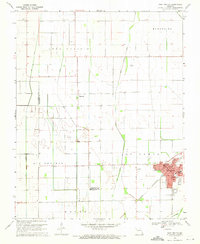
1969 Map of East Prairie
USGS Topo · Published 1971About this map
East Prairie serves as the primary hub in this Mississippi County survey, showing the town's dense residential grid and institutional landmarks just before the 1970s. The landscape is defined by the agricultural expanses of Big Prairie and Long Prairie, which are crisscrossed by a complex drainage network including Maple Slough Ditch and Ash DITCH. These waterways illustrate the intensive land management required for farming in the Missouri Bootheel region. Outside the main town, smaller settlements like Bement and Dogwood appear as quiet rural junctions. Genealogists can locate several schools such as Doyle Sch and Webb Sch, along with family-named sites like Armour Cem. The St Louis Southwestern railroad corridor cuts diagonally through the southern sections, anchoring the regional transport of the era alongside a small local Landing Strip.
Find a feature on this map
42 named features on this map. Tap any name to fly to it.
Don’t see what you’re looking for? This feature index may not catch every label — zoom into the map to look around manually.
Map Details
Editions of this 1969 East Prairie Map
This is the sole edition of this map. No revisions or reprints were ever made.
Other maps of this area

1931 · Sikeston
USGS Topo · 1:62,500

1934 · Sikeston
USGS Topo · 1:62,500

1939 · Sikeston
USGS Topo · 1:62,500

1939 · Charleston
USGS Topo · 1:62,500

1939 · New Madrid
USGS Topo · 1:62,500

1939 · Bayouville
USGS Topo · 1:62,500

1954 · Charleston
USGS Topo · 1:62,500

1954 · New Madrid
USGS Topo · 1:62,500

1955 · Bayouville
USGS Topo · 1:62,500

1956 · Dyersburg
USGS Topo · 1:250,000