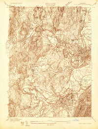
1935 Map of Easthampton
USGS Topo · Published 1935About this map
Northampton and Easthampton dominate this mid-1930s landscape, illustrating a period of significant institutional and industrial density along the Mill River. Large-scale facilities such as the U S Veterans Administration Facility No 95, the Northampton State Hospital, and the Hampshire County Sanitorium occupy prominent positions, reflecting the era's regional importance as a center for healthcare and education, further evidenced by Williston Academy and the Clarke School For The Deaf.
Find a feature on this map
68 named features on this map. Tap any name to fly to it.
Don’t see what you’re looking for? This feature index may not catch every label — zoom into the map to look around manually.
Map Details
Editions of this 1935 Easthampton Map
This is the sole edition of this map. No revisions or reprints were ever made.
Other maps of this area

1885 · Northampton
USGS Topo · 1:62,500

1886 · Springfield
USGS Topo · 1:62,500

1886 · Chesterfield
USGS Topo · 1:62,500

1886 · Northampton
USGS Topo · 1:62,500

1887 · Granville
USGS Topo · 1:62,500

1888 · Chesterfield
USGS Topo · 1:62,500

1889 · Springfield
USGS Topo · 1:62,500

1889 · Granville
USGS Topo · 1:62,500

1891 · Northampton
USGS Topo · 1:62,500

1893 · Northampton
USGS Topo · 1:62,500