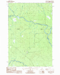
1986 Map of Eastman Brook
USGS Topo · Published 1986About this map
The confluence of the Northwest Branch River and the Southwest Branch St John River defines this heavily forested corner of northern Maine. Situated along the boundary between Aroostook and Somerset Counties, the landscape is primarily characterized by township divisions T 11 R 17 Wels and T 10 R 17 Wels. The absence of developed towns emphasizes the region's historical reliance on timber and natural resources, evidenced by a network of Private Roads and local Gravel Pits. Waterways like Eastman Brook, Bean Brook, and Oak Brook provide the primary geographic markers across the undulating terrain. This 1986 survey represents the area just as modern forest management practices were being documented on provisional topographic sheets, capturing the St John River system in its remote, industrial timberland state.
Find a feature on this map
13 named features on this map. Tap any name to fly to it.
Don’t see what you’re looking for? This feature index may not catch every label — zoom into the map to look around manually.
Map Details
Editions of this 1986 Eastman Brook Map
This is the sole edition of this map. No revisions or reprints were ever made.
Other maps of this area

1954 · Baker Lake
USGS Topo · 1:62,500

1954 · Presque Isle
USGS Topo · 1:250,000

1955 · Beaver Pond
USGS Topo · 1:62,500

1957 · Hardwood Mountain
USGS Topo · 1:62,500

1958 · Presque Isle
USGS Topo · 1:250,000

1960 · Presque Isle
USGS Topo · 1:250,000

1962 · Baker Lake
USGS Topo · 1:62,500

1962 · Quebec
USGS Topo · 1:250,000
1977 · Burntland Pond
USGS Topo · 1:24,000
1986 · Mary L Pond
USGS Topo · 1:24,000