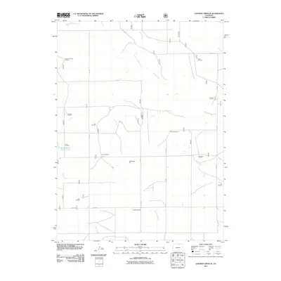
2011 Map of Eastman Creek SE
USGS Topo · Published 2011About this map
Wildhorse Tit rises as a prominent landmark in this high-plains landscape of Weld County, defining a region where water management is the primary driver of settlement patterns. The map detail highlights an extensive network of named windmills, such as the McNamara Junior Windmill, Vivian Windmill, and Fourteen Windmill, which signify the critical importance of groundwater for ranching operations. Drainage is dominated by the ephemeral Coal Creek and the meandering Willow Creek, with the West Fork Willow Creek joining the main stem in the northern reaches. This 2011 survey captures the area’s rural character through its grid of county roads and localized water features like Gunn Reservoir Number Three, providing a clear picture of the infrastructure required for agricultural survival in this semi-arid part of Colorado.
Find a feature on this map
28 named features on this map. Tap any name to fly to it.
Don’t see what you’re looking for? This feature index may not catch every label — zoom into the map to look around manually.
Map Details
Editions of this 2011 Eastman Creek SE Map
This is the sole edition of this map. No revisions or reprints were ever made.
Other maps of this area
1908 · Eaton
USGS Topo · 1:125,000
1910 · Eaton
USGS Topo · 1:125,000
1954 · Greeley
USGS Topo · 1:250,000
1957 · Greeley
USGS Topo · 1:250,000
1958 · Greeley
USGS Topo · 1:250,000
1960 · Purcell
USGS Topo · 1:24,000
1960 · Antelope Reservoir
USGS Topo · 1:24,000
1961 · Greeley
USGS Topo · 1:250,000
1964 · Greeley
USGS Topo · 1:250,000
1965 · Greeley
USGS Topo · 1:250,000