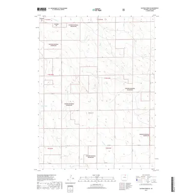
2019 Map of Eastman Creek SE
USGS Topo · Published 2019About this map
Pawnee National Grassland dominates this high plains landscape in Weld County, revealing a vast network of section-line roads and seasonal drainage systems. The terrain is defined by the ephemeral winding of W Fork Willow Cr and Willow Creek, which feed into the northern stretches of the map. A notable hydrological feature is Gunn Reservoir Number Three in the western portion, reflecting the vital importance of water management in this arid grazing environment. Local landmarks such as the distinctively named Wildhorse Tit and the course of Wildhorse Cr provide orientation points within the expansive grassland. The grid of county roads, including Co RD 122 and Co RD 106, underscores the structured land division that has shaped this region since its early settlement.
Find a feature on this map
25 named features on this map. Tap any name to fly to it.
Don’t see what you’re looking for? This feature index may not catch every label — zoom into the map to look around manually.
Map Details
Editions of this 2019 Eastman Creek SE Map
This is the sole edition of this map. No revisions or reprints were ever made.
Other maps of this area
1908 · Eaton
USGS Topo · 1:125,000
1910 · Eaton
USGS Topo · 1:125,000
1954 · Greeley
USGS Topo · 1:250,000
1957 · Greeley
USGS Topo · 1:250,000
1958 · Greeley
USGS Topo · 1:250,000
1960 · Purcell
USGS Topo · 1:24,000
1960 · Antelope Reservoir
USGS Topo · 1:24,000
1961 · Greeley
USGS Topo · 1:250,000
1964 · Greeley
USGS Topo · 1:250,000
1965 · Greeley
USGS Topo · 1:250,000