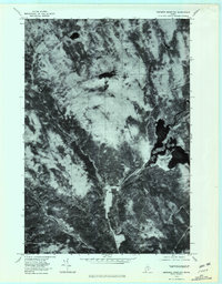
1978 Map of Ebeemee Mountain
USGS Topo · Published 1981About this map
Ebeemee Mountain and its surrounding Maine woodlands are defined by a complex network of waterways that converge in the southern portion of this orthophotoquad. The Middle Branch Pleasant River and West Branch Pleasant River flow through the timberlands to meet the East Branch Pleasant River near the small settlement of Prairie. This confluence creates a hub for the local landscape, reflecting the traditional reliance on river systems for movement and resource management in Piscataquis County.
Find a feature on this map
9 named features on this map. Tap any name to fly to it.
Don’t see what you’re looking for? This feature index may not catch every label — zoom into the map to look around manually.
Map Details
Editions of this 1978 Ebeemee Mountain Map
This is the sole edition of this map. No revisions or reprints were ever made.
Other maps of this area

1940 · Sebec
USGS Topo · 1:48,000

1943 · Sebec
USGS Topo · 1:62,500

1947 · Schoodic
USGS Topo · 1:62,500

1949 · Schoodic
USGS Topo · 1:62,500

1951 · Norcross
USGS Topo · 1:62,500

1952 · Jo-Mary Mountain
USGS Topo · 1:62,500

1954 · Millinocket
USGS Topo · 1:250,000

1958 · Millinocket
USGS Topo · 1:250,000

1960 · Millinocket
USGS Topo · 1:250,000
1978 · Silver Lake
USGS Topo · 1:24,000
Featured Places
- Brownville, ME
- Ebeemee Township, ME
- Mooresville, Katahdin Iron Works Township
- TB R10 WELS, ME
- Prairie, Ebeemee Township