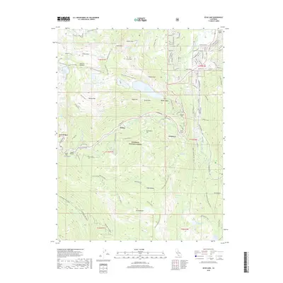
2018 Map of Echo Lake
USGS Topo · Published 2018About this map
Phillips and Nebelhorn sit along the historic passage through the Sierra Nevada, marking a landscape defined by high-elevation lakes and meadow systems within the Eldorado National Forest. The map documents a dense network of water bodies, from the sprawling Lower Echo Lake and Echo Lake to smaller alpine features like Cup Lake, Triangle Lake, and Lake of the Woods. The eastern portion of the quadrangle shows the suburban development of Lake Valley, with street names such as Bakersfield St and Navahoe Dr reflecting mid-century growth patterns near the Upper Truckee River. This 2018 survey also tracks numerous meadows essential to the local hydrology, including Benwood Meadow, Bryan Meadow, and Round Meadow, providing a detailed view of the natural and residential geography at Echo Summit.
Find a feature on this map
121 named features on this map. Tap any name to fly to it.
Don’t see what you’re looking for? This feature index may not catch every label — zoom into the map to look around manually.
Map Details
Editions of this 2018 Echo Lake Map
This is the sole edition of this map. No revisions or reprints were ever made.
Other maps of this area

1889 · Pyramid Peak
USGS Topo · 1:125,000

1889 · Markleeville
USGS Topo · 1:125,000

1891 · Markleeville
USGS Topo · 1:125,000

1891 · Pyramid Peak
USGS Topo · 1:125,000

1893 · Markleeville
USGS Topo · 1:125,000

1895 · Pyramid Peak
USGS Topo · 1:125,000

1896 · Pyramid Peak
USGS Topo · 1:125,000

1947 · Sacramento
USGS Topo · 1:250,000

1948 · Walker Lake
USGS Topo · 1:250,000

1948 · Sacramento
USGS Topo · 1:250,000