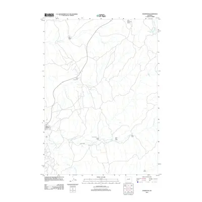
2012 Map of Edgerton
USGS Topo · Published 2012About this map
Edgerton and its surrounding high plains landscape are defined by a network of ephemeral watercourses and energy production as it stood in the early 21st century. The town site is situated near the confluence of Salt Cr and Cottonwood Cr, while the expansive East Salt Creek Oil Field occupies the central terrain, illustrating the region's long-standing reliance on resource extraction. The topography is intricately carved by numerous named draws, such as Joe Begant Draw, Dead Dog Draw, and Ford Draw, which direct drainage toward the primary creek beds.
Find a feature on this map
18 named features on this map. Tap any name to fly to it.
Don’t see what you’re looking for? This feature index may not catch every label — zoom into the map to look around manually.
Map Details
Editions of this 2012 Edgerton Map
This is the sole edition of this map. No revisions or reprints were ever made.
Other maps of this area

1954 · Linch
USGS Topo · 1:24,000

1954 · Taylor Ranch
USGS Topo · 1:24,000

1955 · Arminto
USGS Topo · 1:250,000

1958 · Arminto
USGS Topo · 1:250,000

1959 · Edgerton
USGS Topo · 1:62,500

1961 · Dead Woman Crossing
USGS Topo · 1:24,000

1962 · Arminto
USGS Topo · 1:250,000

1968 · Midwest
USGS Topo · 1:24,000

1968 · Salt Creek
USGS Topo · 1:24,000
1981 · Midwest
USGS Topo · 1:100,000