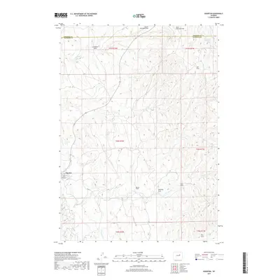
2017 Map of Edgerton
USGS Topo · Published 2017About this map
Edgerton stands as a focal point in this high plains landscape along the Johnson Co Natrona Co line. The town's layout, centered on Center St and featuring a local Po, is surrounded by a complex system of seasonal drainage draws and intermittent streams. These geological features, including Joe Begant Draw, Dead Dog Draw, and King Draw, define the hydrology of the region as they feed into larger watercourses like Salt Creek and Cottonwood Creek. The presence of the Meadow Cr Reservoir in the northeast corner highlights the critical role of water management in this arid ranching and energy-producing environment. State Highway 387 and Co Rd 117 provide the primary connections through the undulating terrain of townships T41N to T39N.
Find a feature on this map
25 named features on this map. Tap any name to fly to it.
Don’t see what you’re looking for? This feature index may not catch every label — zoom into the map to look around manually.
Map Details
Editions of this 2017 Edgerton Map
This is the sole edition of this map. No revisions or reprints were ever made.
Other maps of this area

1954 · Linch
USGS Topo · 1:24,000

1954 · Taylor Ranch
USGS Topo · 1:24,000

1955 · Arminto
USGS Topo · 1:250,000

1958 · Arminto
USGS Topo · 1:250,000

1959 · Edgerton
USGS Topo · 1:62,500

1961 · Dead Woman Crossing
USGS Topo · 1:24,000

1962 · Arminto
USGS Topo · 1:250,000

1968 · Midwest
USGS Topo · 1:24,000

1968 · Salt Creek
USGS Topo · 1:24,000
1981 · Midwest
USGS Topo · 1:100,000