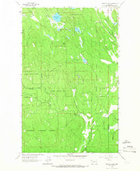
1963 Map of Edna Mountain
USGS Topo · Published 1966About this map
Kootenai National Forest dominates this mid-century landscape in northwest Montana, centered on the prominent peak of Edna Mountain. The terrain is defined by a complex drainage system where Fortine Creek and its many tributaries, such as Hamilton Creek and Edna Creek, carve through the timbered highlands. Near the northern boundary, Marl Lake, Deep Lake, and Loon Lake sit among the ridges, while the Great Northern railway line follows the eastern valley floor, passing the Ant Plat landmark. This period shows a landscape primarily managed for natural resources and transportation, evidenced by the Gravel Pit and a Gaging Sta on Fortine Creek. The small community presence near the Flathead County line is marked by the Trego Sch, illustrating the sparse but established settlement patterns of the 1960s.
Find a feature on this map
26 named features on this map. Tap any name to fly to it.
Don’t see what you’re looking for? This feature index may not catch every label — zoom into the map to look around manually.
Map Details
Editions of this 1963 Edna Mountain Map
2 editions found
Other maps of this area

1913 · Stryker
USGS Topo · 1:125,000

1916 · Stryker
USGS Topo · 1:125,000

1957 · Kalispell
USGS Topo · 1:250,000

1960 · Kalispell
USGS Topo · 1:250,000

1961 · Kalispell
USGS Topo · 1:250,000

1963 · Mount Marston
USGS Topo · 1:24,000

1963 · Eureka South
USGS Topo · 1:24,000

1963 · Davis Mountain
USGS Topo · 1:24,000

1963 · Stryker
USGS Topo · 1:24,000
1963 · Skillet Mountain
USGS Topo · 1:24,000