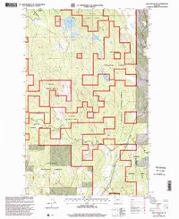
1997 Map of Edna Mountain
USGS Topo · Published 2000About this map
The Kootenai National Forest dominates this landscape in Lincoln County, where the high terrain of Edna Mountain overlooks a complex network of glacial lakes and drainage basins. During the late twentieth century, the area maintained its character as a managed forest environment, evidenced by the numerous 4wd tracks and the presence of a Gravel Pit near the headwaters of Edna Creek. The eastern boundary of the forest is traced by Murphy Creek and Fortine Creek, where the small settlement at Ant Flat and the Trego School mark the transition from protected federal lands to local community hubs. This map reveals a high-elevation water system, from the northern Marl Lake and Loon Lake down through the southern reaches of Beaver Creek and Thor Creek, illustrating the natural hydrologic patterns that have long defined the Stillwater River watershed.
Find a feature on this map
24 named features on this map. Tap any name to fly to it.
Don’t see what you’re looking for? This feature index may not catch every label — zoom into the map to look around manually.
Map Details
Editions of this 1997 Edna Mountain Map
This is the sole edition of this map. No revisions or reprints were ever made.
Other maps of this area

1913 · Stryker
USGS Topo · 1:125,000

1916 · Stryker
USGS Topo · 1:125,000

1957 · Kalispell
USGS Topo · 1:250,000

1960 · Kalispell
USGS Topo · 1:250,000

1961 · Kalispell
USGS Topo · 1:250,000

1963 · Mount Marston
USGS Topo · 1:24,000

1963 · Eureka South
USGS Topo · 1:24,000

1963 · Davis Mountain
USGS Topo · 1:24,000

1963 · Stryker
USGS Topo · 1:24,000
1963 · Skillet Mountain
USGS Topo · 1:24,000