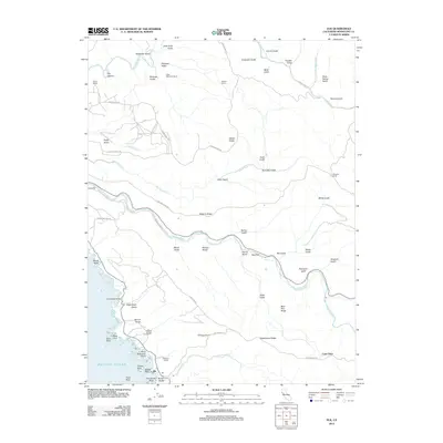
2012 Map of Elk
USGS Topo · Published 2012About this map
The coastal village of Elk anchors this Mendocino County landscape, where the land drops sharply to the Pacific Ocean at landmarks like Cuffeys Point and Saint Anthonys Point. The topography is defined by high coastal benches such as Albion Ridge and Navarro Ridge, which separate the major drainages of the Albion River and the Navarro River. Inland, the map reveals a network of working lands and family-named holdings, including Table Mountain Ranch, McMaster Ranch, and Donahue Ranch. This survey captures the characteristic rugged access of the Northern California coast, documented through steep routes like the Cavanaugh Grade and the winding course of Greenwood Rd as it follows Greenwood Cr toward the sea. Notable coastal hazards and features like Wharf Rock, Casket Rock, and Gunderson Rock reflect the area's history of maritime navigation and early logging-era shipping points.
Find a feature on this map
69 named features on this map. Tap any name to fly to it.
Don’t see what you’re looking for? This feature index may not catch every label — zoom into the map to look around manually.
Map Details
Editions of this 2012 Elk Map
This is the sole edition of this map. No revisions or reprints were ever made.
Other maps of this area

1920 · Glenblair
USGS Topo · 1:62,500

1920 · Fort Bragg
USGS Topo · 1:62,500

1943 · Glenblair
USGS Topo · 1:62,500

1943 · Fort Bragg
USGS Topo · 1:62,500

1943 · Albion
USGS Topo · 1:62,500

1943 · Navarro
USGS Topo · 1:62,500

1944 · Saddle Point
USGS Topo · 1:62,500

1957 · Ukiah
USGS Topo · 1:250,000

1960 · Ukiah
USGS Topo · 1:250,000
1960 · Elk
USGS Topo · 1:24,000