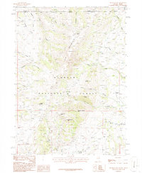
1986 Map of Elk Mountain
USGS Topo · Published 1987About this map
Elk Mountain dominates the center of this high-elevation landscape where Humboldt National Forest spans the border between Idaho and Nevada. The terrain is defined by a complex drainage system, where Ross Creek and Higgins Draw flow through the northwest while Willow Creek and North Creek carve paths through the eastern slopes. A trio of animal-named landmarks—Mahogany Elephant Butte, Red Elephant Butte, and White Elephant Butte—stand as distinct geological markers in the southern portion of the quadrangle. Human activity in this remote region is evidenced by the Twin Meadows Ranch in the northeast and scattered Prospects near O'Neil Creek, indicating the intersection of cattle ranching and mineral exploration. The map also captures the tri-county junction of Owyhee, Elko, and Twin Falls counties, a significant survey point for regional historians.
Find a feature on this map
36 named features on this map. Tap any name to fly to it.
Don’t see what you’re looking for? This feature index may not catch every label — zoom into the map to look around manually.
Map Details
Editions of this 1986 Elk Mountain Map
This is the sole edition of this map. No revisions or reprints were ever made.
Other maps of this area

1955 · Twin Falls
USGS Topo · 1:250,000

1955 · Wells
USGS Topo · 1:250,000

1957 · Contact
USGS Topo · 1:62,500

1957 · Elk Mountain
USGS Topo · 1:62,500

1958 · Wells
USGS Topo · 1:250,000

1958 · Twin Falls
USGS Topo · 1:250,000

1961 · Wells
USGS Topo · 1:250,000

1978 · Taylor Canyon
USGS Topo · 1:24,000
1979 · Three Creek
USGS Topo · 1:24,000
1980 · Curtis Draw
USGS Topo · 1:24,000