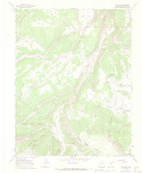
1965 Map of Elk Park
USGS Topo · Published 1972About this map
The Continental Divide snake through this high-altitude landscape of Saguache County, forming the literal and figurative backbone of the region. The map highlights the intersection of the Gunnison National Forest and Rio Grande National Forest, where the terrain drops from summits like Table Mountain into drainage basins including Cochetopa Creek and the North Fork Saguache Creek. A significant portion of the southern area is dedicated to the La Garita Wilderness, a designation that reflects the preserved nature of the high peaks and deep valleys like Cañon Hondo.
Find a feature on this map
25 named features on this map. Tap any name to fly to it.
Don’t see what you’re looking for? This feature index may not catch every label — zoom into the map to look around manually.
Map Details
Editions of this 1965 Elk Park Map
4 editions found
Other maps of this area

1914 · Creede
USGS Topo · 1:125,000

1916 · Creede
USGS Topo · 1:125,000

1945 · Durango
USGS Topo · 1:250,000

1953 · Durango
USGS Topo · 1:250,000

1954 · Durango
USGS Topo · 1:250,000

1956 · Montrose
USGS Topo · 1:250,000

1959 · Montrose
USGS Topo · 1:250,000

1959 · Creede
USGS Topo · 1:62,500

1960 · Montrose
USGS Topo · 1:250,000

1961 · Durango
USGS Topo · 1:250,000