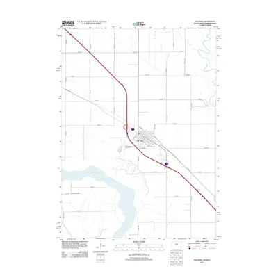
2012 Map of Elk Point
USGS Topo · Published 2012About this map
Elk Point serves as the focal point of this tri-state border region, situated along a prominent bend of the Missouri River where South Dakota, Nebraska, and Iowa meet. The town's grid is clearly defined by historical thoroughfares like Harrison St and Clay St, with the Po and Saint Joseph Cem marking the community's civic and spiritual centers. The landscape reflects a well-ordered agricultural and transit corridor, shaped by the path of Brule Cr and the marshy reaches of Government Slough. On the Nebraska side of the river, the expansive Ponca State Park stands in contrast to the developed section of the riverbank, providing a look at the preserved Missouri bluffs. This 2012 survey documents the area's modern infrastructure, from the MJ Aviation Airport II to the extensive grid of section-line roads like 473rd Ave and 321st St.
Find a feature on this map
37 named features on this map. Tap any name to fly to it.
Don’t see what you’re looking for? This feature index may not catch every label — zoom into the map to look around manually.
Map Details
Editions of this 2012 Elk Point Map
This is the sole edition of this map. No revisions or reprints were ever made.
Other maps of this area

1898 · Elk Point
USGS Topo · 1:125,000

1901 · Elk Point
USGS Topo · 1:125,000

1907 · Elk Point
USGS Topo · 1:125,000

1955 · Sioux City
USGS Topo · 1:250,000

1958 · Sioux City
USGS Topo · 1:250,000

1959 · Sioux City
USGS Topo · 1:250,000

1963 · Elk Point
USGS Topo · 1:24,000

1963 · Elk Point NE
USGS Topo · 1:24,000

1963 · Jefferson
USGS Topo · 1:24,000

1964 · Burbank
USGS Topo · 1:24,000