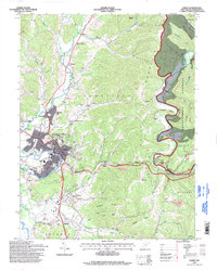
1995 Map of Elkins
USGS Topo · Published 1998About this map
The Tygart Valley River and its floodplain provide the foundation for the regional hub of Elkins, shown here in the mid-1990s as a complex junction of rail, education, and light industry. The campus of Davis and Elkins College sits on the heights above the town center, overlooking the Western Maryland RR corridors and landmarks like the Armory and Athletic Field. To the east, the terrain shifts abruptly into the ridges of the Monongahela National Forest, where the deep gorge of Shavers Fork cuts through Cheat Mountain.
Find a feature on this map
80 named features on this map. Tap any name to fly to it.
Don’t see what you’re looking for? This feature index may not catch every label — zoom into the map to look around manually.
Map Details
Editions of this 1995 Elkins Map
This is the sole edition of this map. No revisions or reprints were ever made.
Other maps of this area

1886 · St. George
USGS Topo · 1:125,000

1889 · Beverly
USGS Topo · 1:125,000

1891 · St. George
USGS Topo · 1:125,000

1892 · Beverly
USGS Topo · 1:125,000

1907 · Belington
USGS Topo · 1:62,500

1908 · Parsons
USGS Topo · 1:62,500

1909 · Elkins
USGS Topo · 1:62,500

1922 · Horton
USGS Topo · 1:48,000

1924 · Horton
USGS Topo · 1:62,500

1926 · Parsons
USGS Topo · 1:62,500