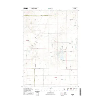
2014 Map of Elmira
USGS Topo · Published 2014About this map
The unincorporated community of Elmira serves as the focal point of this northern Michigan landscape, situated where the borders of Antrim and Otsego Counties meet. This 2014 survey reveals a transition from agricultural fields and grid-patterned roads to a kettle-lake dotted terrain to the east and south. A dense cluster of small water bodies, including Martin Lake, Pettifor Lake, and the uniquely named Lake Twentyseven, indicates the glacial topography that defines this region. The map provides significant detail for genealogists, marking the locations of Saint Thomas Cem, Hallock Cem, and Hayes Cem across the township lines.
Find a feature on this map
71 named features on this map. Tap any name to fly to it.
Don’t see what you’re looking for? This feature index may not catch every label — zoom into the map to look around manually.
Map Details
Editions of this 2014 Elmira Map
This is the sole edition of this map. No revisions or reprints were ever made.
Other maps of this area

1949 · Otsego Lake
USGS Topo · 1:62,500

1951 · Otsego Lake
USGS Topo · 1:24,000

1954 · Gaylord
USGS Topo · 1:62,500

1954 · Traverse City
USGS Topo · 1:250,000

1955 · Cheboygan
USGS Topo · 1:250,000

1956 · Alba
USGS Topo · 1:62,500

1958 · Cheboygan
USGS Topo · 1:250,000

1958 · Traverse City
USGS Topo · 1:250,000

1961 · Boyne Falls
USGS Topo · 1:62,500
1975 · Gaylord SW
USGS Topo · 1:24,000