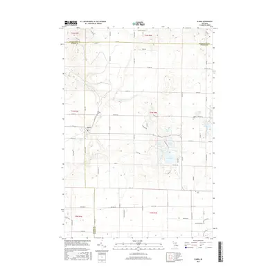
2017 Map of Elmira
USGS Topo · Published 2017About this map
Elmira serves as the primary hub in this portion of Otsego County, situated at the junction of M-32 and several key rural corridors. The township's landscape is characterized by its numerous glacial kettle lakes and wetlands, including clusters such as West Lake, Martin Lake, Deer Lake, and the distinctly named Lake Twentyseven. To the north, the headwaters of the S Br Boyne River emerge from the high ground. Genealogists will find several notable burial sites throughout the township, such as Saint Thomas Cem, Hallock Cem, and Hayes Cem, which reflect the early settlement patterns of this timber and agricultural region. The land is crisscrossed by an orderly grid of local roads, many of which, like Webster Rd and Camp Ten Rd, follow the established section lines of the Public Land Survey System.
Find a feature on this map
78 named features on this map. Tap any name to fly to it.
Don’t see what you’re looking for? This feature index may not catch every label — zoom into the map to look around manually.
Map Details
Editions of this 2017 Elmira Map
This is the sole edition of this map. No revisions or reprints were ever made.
Other maps of this area

1949 · Otsego Lake
USGS Topo · 1:62,500

1951 · Otsego Lake
USGS Topo · 1:24,000

1954 · Gaylord
USGS Topo · 1:62,500

1954 · Traverse City
USGS Topo · 1:250,000

1955 · Cheboygan
USGS Topo · 1:250,000

1956 · Alba
USGS Topo · 1:62,500

1958 · Cheboygan
USGS Topo · 1:250,000

1958 · Traverse City
USGS Topo · 1:250,000

1961 · Boyne Falls
USGS Topo · 1:62,500
1975 · Gaylord SW
USGS Topo · 1:24,000