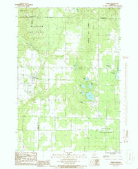
1986 Map of Elmira
USGS Topo · Published 1986About this map
Mackinaw State Forest dominates this section of Northern Michigan, where the boundary lines of Otsego, Antrim, and Charlevoix counties converge. The small settlement of Elmira serves as a local hub, featuring a Substation and proximity to a local Cem. The landscape is defined by the Boyne Valley and the South Branch Boyne River, alongside a high concentration of glacial lakes including Lake 27, Deer Lake, and Martin Lake. An Old Railroad Grade suggests the region's historic dependence on timber transport, while modern infrastructure like a Pipeline, a Pumping Station, and the WKPK Radio Tower indicate the mid-1980s transition toward industrial and communication utility. A Public Golf Course and numerous small lakes highlight the area's established role in regional recreation.
Find a feature on this map
28 named features on this map. Tap any name to fly to it.
Don’t see what you’re looking for? This feature index may not catch every label — zoom into the map to look around manually.
Map Details
Editions of this 1986 Elmira Map
This is the sole edition of this map. No revisions or reprints were ever made.
Other maps of this area

1949 · Otsego Lake
USGS Topo · 1:62,500

1951 · Otsego Lake
USGS Topo · 1:24,000

1954 · Gaylord
USGS Topo · 1:62,500

1954 · Traverse City
USGS Topo · 1:250,000

1955 · Cheboygan
USGS Topo · 1:250,000

1956 · Alba
USGS Topo · 1:62,500

1958 · Cheboygan
USGS Topo · 1:250,000

1958 · Traverse City
USGS Topo · 1:250,000

1961 · Boyne Falls
USGS Topo · 1:62,500
1975 · Gaylord SW
USGS Topo · 1:24,000