1941 Map of Empire
USGS Topo · Published 1941About this map
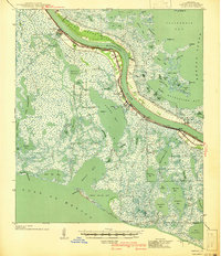
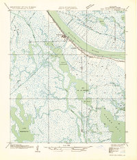
The Mississippi River defines the geography of Plaquemines Parish in the late 1930s, winding through a landscape dominated by marshland, bayous, and a critical river-rail transport corridor. This survey shows the primary settlements concentrated along the New Orleans and Lower Coast River Road, including the industrial hub of Port Sulphur, and the riverfront communities of Empire and Buras. These towns are anchored by the New Orleans and Lower Coast RR, which parallels the levee system. Beyond the protected riverbanks, the land dissolves into a complex network of coastal waters, from Bastian Bay to Quarantine Bay. Local landmarks like the Pt Pleasant Cem and Swartze Sch provide specific points of interest for genealogists tracing family histories in these delta communities before significant coastal erosion changed the shoreline.
Find a feature on this map
87 named features on this map. Tap any name to fly to it.
Don’t see what you’re looking for? This feature index may not catch every label — zoom into the map to look around manually.
Map Details
Editions of this 1941 Empire Map
This is the sole edition of this map. No revisions or reprints were ever made.
Other maps of this area

1891 · Pointe a La Hache
USGS Topo · 1:62,500

1892 · Quarantine
USGS Topo · 1:62,500

1892 · Pointe a La Hache
USGS Topo · 1:62,500
1893 · La Fortuna
USGS Topo · 1:62,500
1893 · Forts
USGS Topo · 1:62,500

1893 · Fort Livingston
USGS Topo · 1:62,500

1893 · Dime
USGS Topo · 1:62,500
1893 · West Delta
USGS Topo · 1:62,500
1935 · Port Sulphur
USGS Topo · 1:31,680

1935 · Bastian Bay
USGS Topo · 1:31,680