
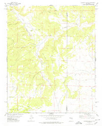
1978 Map of Encino
USGS Topo · Published 1978About this map
Encino serves as a central hub on this high plains landscape, situated at the junction of Highway 60 and Highway 285. The town's grid is small but defined, featuring an Athletic Field and local burial grounds including the Guadalupe Cem and a second Cem to the south. The southern edge of the town is bordered by the Atchison Topeka and Santa Fe railroad, which tracks southeast toward the small stop at Carnero. The terrain is characterized by a significant geological Depression to the east, where the land sinks below the surrounding contours of the Amarillo Draw. Several Gravel Pits suggest local extraction industries, while scattered features like a Tank and Well indicate the infrastructure required for life and ranching in this arid New Mexico interior during the late 1970s.
Find a feature on this map
14 named features on this map. Tap any name to fly to it.
Don’t see what you’re looking for? This feature index may not catch every label — zoom into the map to look around manually.
Map Details
Editions of this 1978 Encino Map
This is the sole edition of this map. No revisions or reprints were ever made.
Other maps of this area

1954 · Fort Sumner
USGS Topo · 1:250,000

1958 · Fort Sumner
USGS Topo · 1:250,000

1978 · North Lucy
USGS Topo · 1:24,000

1978 · Santa Barbara Lake
USGS Topo · 1:24,000

1978 · Tejon
USGS Topo · 1:24,000

1978 · Santo Nino Canyon
USGS Topo · 1:24,000

1978 · Negra SE
USGS Topo · 1:24,000

1978 · Negra
USGS Topo · 1:24,000

1978 · Dunlap Ranch
USGS Topo · 1:24,000
1978 · Pinavete Canyon
USGS Topo · 1:24,000