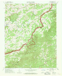
1967 Map of Endicott
USGS Topo · Published 1969About this map
Blue Ridge Parkway winds across the high ridgelines of the Blue Ridge, serving as the primary corridor through this section of the Virginia highlands in the late 1960s. The map illustrates a rural landscape where the border between Franklin and Floyd counties is marked by community landmarks like the County Line Ch. Scattered rural settlements such as Endicott and Pizarro are connected by winding mountain roads, while the Smart View Recreation Area provides a public vista from the Smart View Overlook. Numerous small churches, including Harvestwood Ch and Silverleaf Ch, alongside rural nodes like Kings Store and Woods Store, point to a historically close-knit Appalachian social structure centered on family-named geographic features like Cannaday Gap and Turners Knob.
Find a feature on this map
51 named features on this map. Tap any name to fly to it.
Don’t see what you’re looking for? This feature index may not catch every label — zoom into the map to look around manually.
Map Details
Editions of this 1967 Endicott Map
This is the sole edition of this map. No revisions or reprints were ever made.
Other maps of this area

1890 · Christiansburg
USGS Topo · 1:125,000

1932 · Blacksburg
USGS Topo · 1:48,000

1937 · Blacksburg
USGS Topo · 1:62,500

1950 · Elliston
USGS Topo · 1:62,500

1953 · Winston-Salem
USGS Topo · 1:250,000

1955 · Bluefield
USGS Topo · 1:250,000

1955 · Winston-Salem
USGS Topo · 1:250,000

1957 · Endicott
USGS Topo · 1:62,500

1957 · Floyd
USGS Topo · 1:62,500

1957 · Bluefield
USGS Topo · 1:250,000