
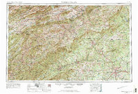
1953 Map of Winston-Salem
USGS Topo · Published 1974About this map
The Blue Ridge and Iron Mountains dominate this 1950s landscape, marking the transition from the North Carolina Piedmont into the Appalachian highlands of Virginia and Tennessee. Winston-Salem serves as the primary urban hub, with the Southern and Norfolk and Western railroads linking smaller industrial and tobacco centers like Mount Airy, Galax, and Elkin. The region’s water systems are well-defined, from the Yadkin River flowing through the Brushy Mountains to the New River and Holston River networks further west.
Find a feature on this map
86 named features on this map. Tap any name to fly to it.
Don’t see what you’re looking for? This feature index may not catch every label — zoom into the map to look around manually.
Map Details
Editions of this 1953 Winston-Salem Map
2 editions found
Other maps of this area

1886 · Grundy
USGS Topo · 1:125,000

1887 · Pocahontas
USGS Topo · 1:125,000

1889 · Hillsville
USGS Topo · 1:125,000

1889 · Wytheville
USGS Topo · 1:125,000

1889 · Wilkesboro
USGS Topo · 1:125,000

1890 · Roanoke
USGS Topo · 1:125,000

1890 · Grundy
USGS Topo · 1:125,000

1890 · Dublin
USGS Topo · 1:125,000

1890 · Christiansburg
USGS Topo · 1:125,000

1891 · Tazewell
USGS Topo · 1:125,000