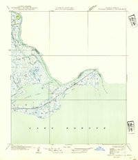
1954 Map of English Lookout
USGS Topo · Published 1954About this map
English Lookout stands as a vital rail outpost on the edge of the Mississippi sound, where the Louisville and Nashville R R traverses a sprawling marshland landscape. This mid-century view reveals a complex network of coastal waterways and bayous that define the border between Hancock County and St. Tammany Parish. The map traces the intricate splitting of the Pearl River into the Old Pearl River and the West Middle River, illustrating how these channels carve through the wetlands to meet Little Lake and Lake Borgne.
Find a feature on this map
29 named features on this map. Tap any name to fly to it.
Don’t see what you’re looking for? This feature index may not catch every label — zoom into the map to look around manually.
Map Details
Editions of this 1954 English Lookout Map
This is the sole edition of this map. No revisions or reprints were ever made.
Other maps of this area

1893 · Rigolets
USGS Topo · 1:62,500

1893 · Toulme
USGS Topo · 1:62,500

1914 · Nicholson
USGS Topo · 1:62,500

1921 · Nicholson
USGS Topo · 1:62,500

1935 · English Lookout
USGS Topo · 1:31,680

1935 · Grand Island Pass
USGS Topo · 1:31,680

1936 · Rigolets
USGS Topo · 1:62,500

1946 · Malheureux Point
USGS Topo · 1:31,680
1946 · Rigolets
USGS Topo · 1:31,680

1949 · Grand Island Pass
USGS Topo · 1:31,680