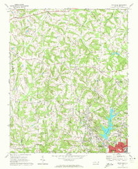
1970 Map of Enochville
USGS Topo · Published 1972About this map
Enochville sits at the heart of this North Carolina landscape, serving as a hub between the rolling drainages of Irish Buffalo Creek and Coddle Creek. The 1970 field check reveals a community anchored by numerous rural congregations, such as St Pauls Ch, West Corinth Ch, and Gospel Light Ch, which are scattered throughout the countryside along with several local cemeteries. The eastern portion of the map is defined by the growing reach of Kannapolis and Landis, where industry and infrastructure are evident in features like the Filtration Plant and Sewage Disposal facility near Lake Kannapolis.
Find a feature on this map
41 named features on this map. Tap any name to fly to it.
Don’t see what you’re looking for? This feature index may not catch every label — zoom into the map to look around manually.
Map Details
Editions of this 1970 Enochville Map
This is the sole edition of this map. No revisions or reprints were ever made.
Other maps of this area

1893 · Statesville
USGS Topo · 1:125,000

1941 · Charlotte
USGS Topo · 1:125,000

1942 · Charlotte
USGS Topo · 1:125,000

1949 · Kannapolis
USGS Topo · 1:24,000

1950 · Concord
USGS Topo · 1:24,000

1953 · Charlotte
USGS Topo · 1:250,000

1954 · Charlotte
USGS Topo · 1:250,000

1960 · Charlotte
USGS Topo · 1:250,000

1962 · Charlotte
USGS Topo · 1:250,000

1969 · Shepherds
USGS Topo · 1:24,000