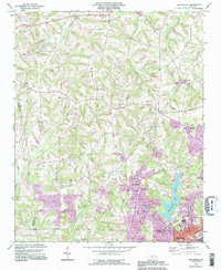
1993 Map of Enochville
USGS Topo · Published 1996About this map
Enochville sits at the heart of this landscape where the borders of Rowan, Iredell, and Cabarrus counties meet. The area is defined by a dense network of country churches that anchored these Piedmont communities, including St Enochs Ch, St Pauls Ch, and West Corinth Ch. To the east, the expansion of Kannapolis and Landis is evident, with suburban developments like Corriher Heights emerging near the Kannapolis Lake shoreline. The transition from agricultural use to more modern infrastructure is marked by a series of pipelines and localized industrial features such as a Filtration Plant Res and various Substations. Smaller rural landmarks, including the Miller Airfield and a notable drag strip, reflect the varied land use of the late 20th century. Numerous waterways like Irish Buffalo Creek and Coddle Creek drain the undulating terrain, which rises to its highest point at Prospect Hill.
Find a feature on this map
46 named features on this map. Tap any name to fly to it.
Don’t see what you’re looking for? This feature index may not catch every label — zoom into the map to look around manually.
Map Details
Editions of this 1993 Enochville Map
This is the sole edition of this map. No revisions or reprints were ever made.
Other maps of this area

1893 · Statesville
USGS Topo · 1:125,000

1941 · Charlotte
USGS Topo · 1:125,000

1942 · Charlotte
USGS Topo · 1:125,000

1949 · Kannapolis
USGS Topo · 1:24,000

1950 · Concord
USGS Topo · 1:24,000

1953 · Charlotte
USGS Topo · 1:250,000

1954 · Charlotte
USGS Topo · 1:250,000

1960 · Charlotte
USGS Topo · 1:250,000

1962 · Charlotte
USGS Topo · 1:250,000

1969 · Shepherds
USGS Topo · 1:24,000