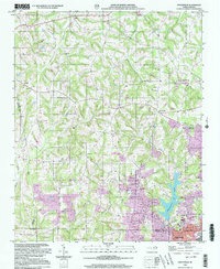
2000 Map of Enochville
USGS Topo · Published 2003About this map
Enochville sits at the heart of this landscape where the borders of Rowan, Iredell, and Cabarrus counties meet. The area is defined by a network of rural communities and significant water features, most notably Lake Kannapolis and Lake Wright. Local history is anchored by numerous country churches, including St Pauls Ch, St Enochs Ch, and West Corinth Ch, which served the surrounding farming and textile populations.
Find a feature on this map
39 named features on this map. Tap any name to fly to it.
Don’t see what you’re looking for? This feature index may not catch every label — zoom into the map to look around manually.
Map Details
Editions of this 2000 Enochville Map
This is the sole edition of this map. No revisions or reprints were ever made.
Other maps of this area

1893 · Statesville
USGS Topo · 1:125,000

1941 · Charlotte
USGS Topo · 1:125,000

1942 · Charlotte
USGS Topo · 1:125,000

1949 · Kannapolis
USGS Topo · 1:24,000

1950 · Concord
USGS Topo · 1:24,000

1953 · Charlotte
USGS Topo · 1:250,000

1954 · Charlotte
USGS Topo · 1:250,000

1960 · Charlotte
USGS Topo · 1:250,000

1962 · Charlotte
USGS Topo · 1:250,000

1969 · Shepherds
USGS Topo · 1:24,000