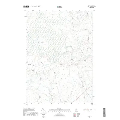
2018 Map of Epping
USGS Topo · Published 2018About this map
Epping and Columbia serve as the primary settlement hubs in this Downeast Maine landscape, where the human footprint is defined by a network of rural roads such as Tibbettstown Rd and Webb District Rd. The terrain is characterized by the expansive Great Heath and numerous specialized wetland environments like Deep Cove Heath and Taylor Branch Swamp. These peatlands and marshes are interrupted by distinct glacial features, including Pineo Ridge and Pigeon Hill, which provided high ground for early roads and cemeteries. Genealogists can find significant local burial sites including Columbia Cem, Mailey Hill Cem, and Forest Hills Cem. The intricate hydrology of the region is evident in the winding courses of the Pleasant River and the Harrington River, along with numerous smaller tributaries like Dorr Brook and Bells Brook that drain the coastal plain.
Find a feature on this map
57 named features on this map. Tap any name to fly to it.
Don’t see what you’re looking for? This feature index may not catch every label — zoom into the map to look around manually.
Map Details
Editions of this 2018 Epping Map
This is the sole edition of this map. No revisions or reprints were ever made.
Other maps of this area

1902 · Cherryfield
USGS Topo · 1:62,500

1904 · Cherryfield
USGS Topo · 1:62,500

1921 · Columbia Falls
USGS Topo · 1:62,500

1921 · Columbia Falls
USGS Topo · 1:62,500

1941 · Columbia Falls
USGS Topo · 1:62,500

1941 · Wesley
USGS Topo · 1:62,500

1941 · Tug Mountain
USGS Topo · 1:62,500

1942 · Cherryfield
USGS Topo · 1:62,500

1942 · Columbia Falls
USGS Topo · 1:62,500

1943 · Tug Mountain
USGS Topo · 1:62,500