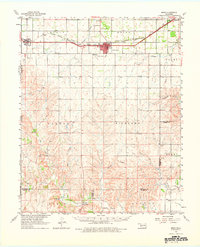
1961 Map of Erick
USGS Topo · Published 1976About this map
The town of Erick serves as a primary hub in western Beckham County during the early 1960s, situated along the Chicago Rock Island and Pacific railroad line. This transportation corridor also connects the smaller community of Texola on the Texas-Oklahoma border and the settlement of Hext to the east. The map captures a transition in local infrastructure, featuring the Haddock Airport and a Drive-in Theater north of the main Erick townsite.
Find a feature on this map
33 named features on this map. Tap any name to fly to it.
Don’t see what you’re looking for? This feature index may not catch every label — zoom into the map to look around manually.
Map Details
Editions of this 1961 Erick Map
2 editions found

Other maps of this area

1954 · Amarillo
USGS Topo · 1:250,000

1954 · Plainview
USGS Topo · 1:250,000

1955 · Lawton
USGS Topo · 1:250,000

1955 · Clinton
USGS Topo · 1:250,000

1957 · Clinton
USGS Topo · 1:250,000

1958 · Amarillo
USGS Topo · 1:250,000

1958 · Plainview
USGS Topo · 1:250,000

1959 · Shinnery Creek
USGS Topo · 1:24,000

1960 · Sweetwater
USGS Topo · 1:62,500

1960 · Sayre
USGS Topo · 1:62,500